
Stiletto Peak Circumambulation
Trail? What trail?

Hey Friends,
This is an essay I wrote while recovering from my finish of 2021 Mogollon Monster. It reflects one of the last weeks of serious training I had before the race. It was fun to revisit this as the plows begin their spring clearing of Highway 20. Summer never comes quickly enough.
Sean
I first saw Stiletto Peak as part of an informal group of self-described “crotchety” hiking friends I somehow found my way into. We hiked into Copper Pass years ago - years before moving to the North Cascades full time.
The peak is also blisteringly obvious from other, nearby excursions like the top of Maple Pass. Any time you can go solo for nearly 20 miles without repeating yourself is probably going to be a good time.
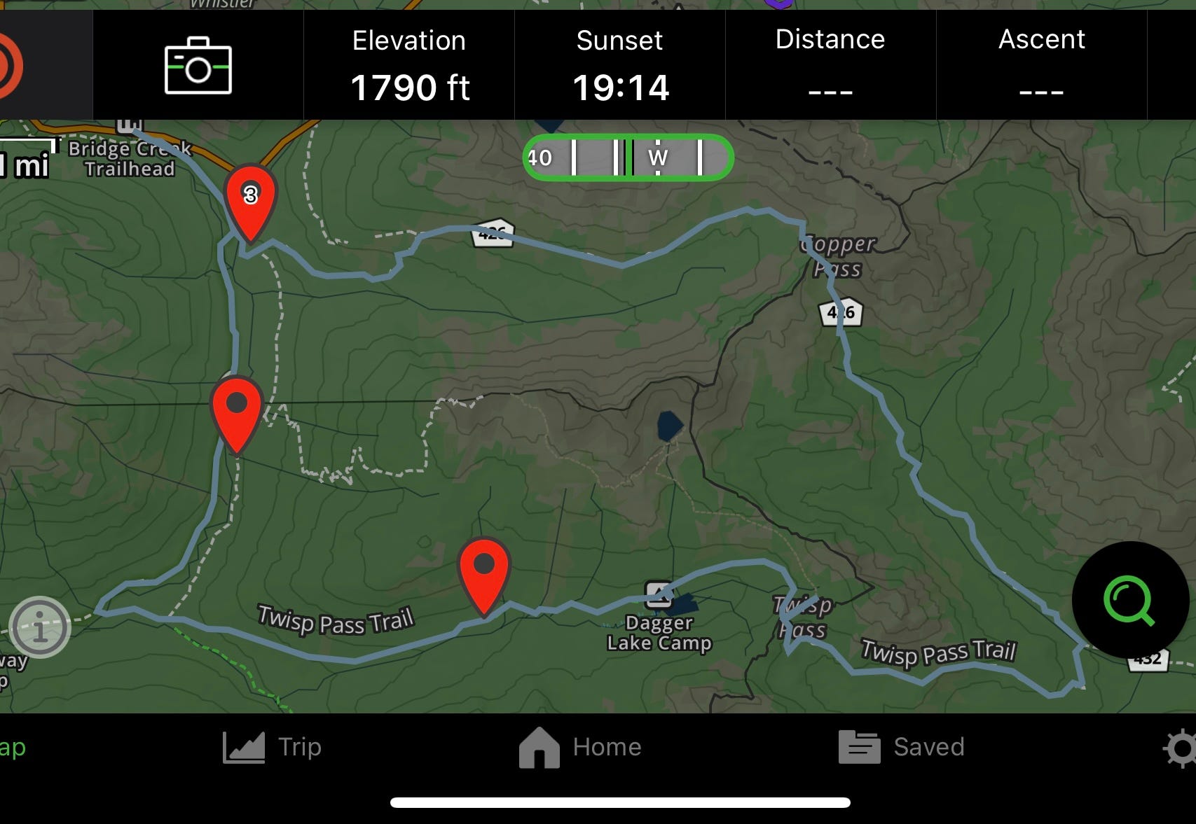
The standard North Cascades / Methow valley topographic map shows a network of trails that run up and around this peak. Not all of those trails are reasonable, but then neither am I. As you’ll soon see.
Before committing to this long run, I wanted to make sure I understood the route. I’ve been from Highway 20 to Copper pass a number of times in recent years. The most remote section - between Copper Pass and Twisp Pass - can be reached by the far back of Twisp River drainage. But that whole area had been inaccessible all summer owing to the fires. That said, it was clear from the USFS website that the trails I would be using were neither in the burned area, nor currently closed. That section would have to be the adventurous part of the trip.
The remaining sections included: Bridge Creek to the Copper Pass Trail, Twisp Pass down to the Fireweed Camps and finally the Fireweed camps back up to Bridge Creek.
Earlier in the month I scouted some old trails running south from Bridge Creek parallel to the PCT. That trail was well overgrown, gorgeous, and filled with downed trees. It looks like it connected to a seriously ridiculous and steep climb up to an old fire lookout, but otherwise had no business receiving any traffic from anyone.
I managed to get up on the trail out to Twisp Pass, and convinced myself that it was passible. I took the PCT back up and was shocked at how - by comparison - it was a veritable freeway. Great.
When I arrived at Bridge creek early in the morning, I convinced myself it was just going to be another scouting run. I hadn’t seen the connector to the usual Copper Pass trail yet, so that was my target.
I’d seen evidence of this trail on the “usual” topo map, suggesting an incredibly steep ascent in a steep alpine meadow to gain the copper pass trail.
This trail had more down trees than switchbacks!
It was absolutely brutal.
By the time I had managed to gain the Copper Pass trail, the clouds had rolled in and I was getting cold. I saw two hikers in the basin just below the pass, who were ambling up towards some other scramble somewhere. Before I knew it, I was utterly alone, pulling on my tights and jacket while starting to panic. I hate the cold.
As I ascended to the pass the sun mercifully came out and I was able to move back to my ball cap and t-shirt. I ate a gel and look out over the Twisp River Valley.
This was the highest point on the entire circumambulation. Given that the sun was out - and scheduled to stay out all day - I took stock in what I had.
Two bottles, a water filter, three gels and a king size payday bar. I had a spare battery and a charging cable for my phone. I had the GPS maps saved. I had my emergency SPOT beacon.
I don’t know if I was lying to myself or what, and I don’t know what lunacy told me to move forward that day, but I started running down from Copper Pass into the Twisp River drainage, only stopping occasionally to take in the views. This trail was uncharted territory.
And it was uncharted for a reason.
About halfway down I realized that there was absolutely no going back. I was already starting to bonk, and realized that climbing back up to Copper Pass would be more hellish than anything that could lay in front of me. Or at least that how I thought about it at the time.
As I approached treeline from above it quickly became apparent that this was an extremely low trafficked trail. Trees were down. The path was steep and full of fist sized scree. It was so steep that I descended into the forest almost before I could process what was happening.
What was happening was the trail was completely covered by wind throw. Trees - huge trees - lay strewn across the ground, completely obliterating any sense of trail there might have been.
Of course, this was the headwaters of the Twisp River - which the trail also followed - so there was a logical way forward.
When I finally hit the bottom of the valley I couldn’t help but laugh. Ahead of me was an entire field of criss crossed logs, and someone had clearly attempted to cut through them. It looked like a crosscut saw had been packed in, two trunks were cut and then abandoned. It was definitely a fools errand.
My GPS helped point the way along the trail. As things turned out, the fallen logs were useful to run across, sparing me from much of the over-under hopping and crawling that you might expect with this much damage.
I was definitely bonking by now, and so crammed half a gel and a quarter of the payday bar, taking special care not to choke. It also occurred to me that bear might be out here - there was no way that humans made it out here with any kind of frequency.
I managed to pick up the trail again as it descended into overgrown riparian bushes. As if to spite my earlier thoughts, I found a large, black beanie stuck to a branch: right on the trail! This immediately told me two things. First, someone had been here and lost their beanie. Second, someone else had to have been through LATER and found the beanie. And this all surely had to have happened this summer, lest the snow take the beanie back to the ground.
I left the unusual relic where it hung and continued until I routinely had only dirt under my feet.
Somehow. I made it to the junction. The USFS folks had put up a sign and some pink tape blocking the path out to the Road’s End trail head along Twisp River Road. Just as well.
I sat down in the pool below the footbridge that cross the river to refill my water balls and finish that half-eaten gel. I couldn’t believe what I’d just done. Alone. On a whim. Without telling anyone what I was doing! (Don’t do that!)
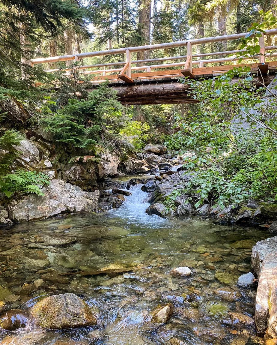
The hike out of the Twisp River Drainage was gorgeous! The trail was nicely maintained, full of beautiful rocky outcroppings and only one downed tree. It was still sunny out and I relished the continued solitude. By this point the entire adventure had become entirely surreal. I refused to acknowledge the crux was over until I was up and over Twisp Pass, running back towards the PCT.
Of course, being ridiculous, low on calories and high on the experience, I started hiking up towards Stiletto lake instead of going down Twisp Pass. I passed at a little tarn, and took a seat under a tree. I looked at my map in dismay. I was starting to bonk again - had less than half my calories left - and despite the perfect conditions, it made no sense to continue exploring.
The Twisp Pass area would have to wait for another time.
I joyfully ran down Twisp pass - still not seeing a soul until I reached the stock camp at Dagger Lake. Finally! People! I couldn’t believe it. I knew at this point that all I had to do was run it in. Even if “it” was another 8 or 10 miles.
The downhill from Dagger Lake was also clear, and eventually turned into trail that I had been on recently. I picked up speed, running through old burns and familiar sights.
At the Fireweed camps I stopped again to collect water. PCT thru-hikers were out in force and by now the sun was beginning to near the horizon.
The slog up the PCT towards Bridge Creek had way more rocks than I remember, and the shade of the tree cover made it feel later than it was.
I finished my last gel just in time to see two ladies picking berries not a quarter mile from the trailhead. I smiled as they scowled. I’m not sure what happened, but I get the sense that I interrupted something. At this point, I couldn’t have cared less.
I stopped at the Mazama store with an hour or so to spare. I ordered two pastries and a beer and sat alone at a table in the patio watched some young climbers from Seattle pour over Brian’s guide book and talk about what they had done that day.
It’s an odd feeling. Sitting there, back in normal life, having randomly accomplished something I’d been eyeing for so long - having seen that much properly bad trail - and now just getting to sit and relax.
20ish miles is one thing. Steep climbing is another. Route finding and the mental energy expended on being “alert” or “vigilant” - despite being an idiot about calories and telling people where my plans - makes it really hard to “reenter” life even having only been gone for a few hours.
It’s that feeling - a sort of calm tinged by an inexplicable sadness - that lets you know that Adventure was had.